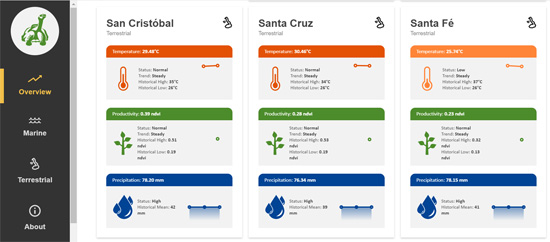
Galápagos Conservancy is pleased to announce the launch of Galápagos Vital Signs, a satellite-based monitoring system of environmental indicators — including temperature, precipitation, and plant productivity — for land- and sea-based regions across the Galápagos archipelago. The mission of Vital Signs is to provide up-to-date information on biodiversity and environmental indicators in the Galápagos Islands to facilitate ongoing efforts by conservationists, scientists, agriculturists, tour operators, divers, the fishing sector, and others working in the Islands.
Vital Signs can be accessed online at www.galapagosvitalsigns.org, where data are available for the five principal protected zones of the Galápagos Marine Reserve, fourteen major islands, and five principal volcanoes on Isabela Island. For each region, data on the latest available surface temperatures, plant productivity (photosynthetic activity), and precipitation (when available) can be viewed. The datasets are refreshed daily to bi-weekly, depending on the data source, with current conditions summarized in each zone relative to their historic baselines. Raw data are available for download.
The Vital Signs website also contains a robust section of related resources, which include links to the Charles Darwin Foundation’s DataZone, the University of San Francisco Quito’s Galápagos Vegetation Map, the Ecuador Navy Oceanographic Institute’s Marine Data, the Shark Count Galápagos mobile app, resources from NOAA and NASA, and others. The site can be viewed in both English and Spanish.
The creators of Galápagos Vital Signs would like to thank the individuals and institutions in Galápagos that provided input into this first phase of the Vital Signs project. Future phases of the project are planned and will depend on available resources.
Visit Galápagos Vital Signs.