San Cristóbal Island
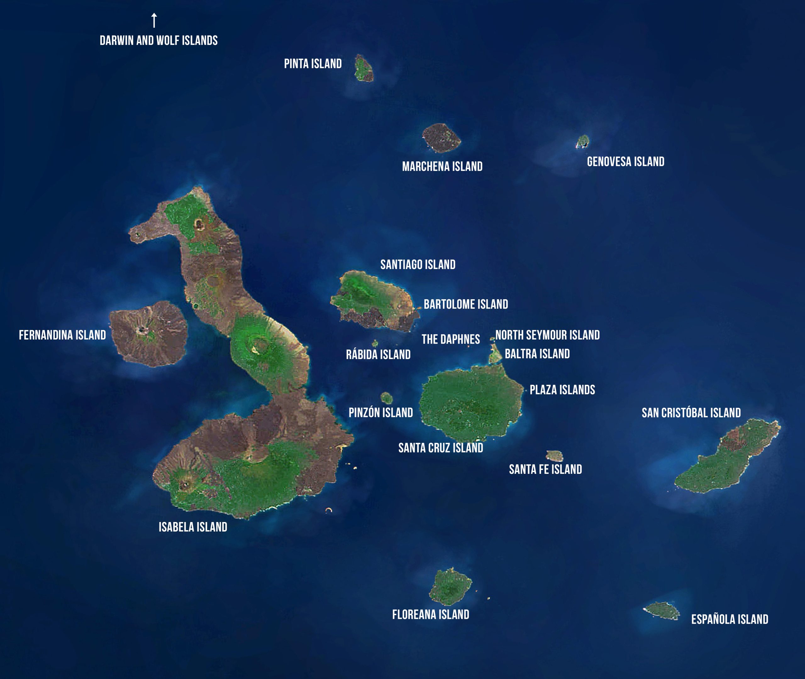
San Cristóbal Island
Area: 557 km2 or 215 mi2
Maximum Altitude: 730 m or 2395 ft
Population: Approximately 6000
HISTORY
San Cristóbal is the fifth largest and easternmost island of Galápagos. It is comprised of three or four fused volcanoes, all extinct. Its name comes from the Patron Saint of seafarers, “St. Christopher.” Its older English name of Chatham is named after John Pitt, 2nd Earl of Chatham. It is home to the oldest permanent settlement of the islands and is the island where Darwin first went ashore in 1835. El Junco, a small lake located near the top of the island, is the only source of permanent fresh water in the islands. This resource led to the early settlement of San Cristóbal, which was home to the islands’ governor when Darwin visited the archipelago in 1835. In 1858, Manuel Cobos and José Monroy formed the Orchillera Company to harvest orchilla moss (a lichen), which was used at that time as a dye. Cobos later formed an agricultural center called “El Progreso” inland from Puerto Baquerizo Moreno, which produced leather from feral cattle, and fish and tortoise oil. A penal colony was built on San Cristóbal Island in 1880 for prisoners from mainland Ecuador. This was eventually run by Cobos. By 1891, sugar cane plantations were established and a sugar factory was put into operation. Cobos ruled “El Progreso” with an iron fist, treating convicts as slaves. Cobos was assassinated by a group of his workers on January 15, 1904, and the prisoners escaped. A fishing company, called “The Predial” flourished from 1952 to 1960. The company stored fish in large refrigerators before shipping them to the continent. The business eventually fell into ruin due to its excessive costs.
TODAY
The town of Puerto Baquerizo Moreno on San Cristóbal is the capital of the Galápagos province. It is home to many government offices, an Ecuadorian Navy facility, and an airport with daily flights to the mainland. There are approximately 5,400 residents, making it home to the second largest human population in Galápagos, after Santa Cruz. The majority of inhabitants make their living in government, tourism, and artisanal fishing. The port town is home to the Galápagos Academic Institute for the Arts and Sciences (GAIAS) of the Universidad San Francisco de Quito (USFQ). This institution serves as a base of operation for local university students to carry out thesis work, and for international students to participate in semester abroad programs. The GNPS Interpretation Center is located near town and provides an excellent source of information for the local community and visitors.
CONSERVATION CHALLENGES
Having a port town with an airport, San Cristóbal is especially susceptible to the potential of new introductions of exotic and sometimes aggressive species. Several of the more serious introductions have occurred first in San Cristóbal, including the black fly (Simulium bipunctata), which was introduced in 1990. This fly has caused problems for farmers in the highlands where it is most common. It sucks blood from both humans and farm animals, leaving a poison that in some cases has resulted in the death of animals. San Cristóbal also has some of the more aggressive introduced plants, including guayaba and blackberry. San Cristóbal is also home to the largest of the fishing fleets in Galápagos, represented by two separate fishing cooperatives. Fisheries and conservation have been at odds at times in the recent history of Galápagos; the challenge today is to work with the fishermen in establishing management strategies for the Marine Reserve that will conserve Galápagos biodiversity and provide a sustainable resource to a portion of the population.
City: Puerto Baquerizo Moreno
Founded by the colonist General Villamil in the mid-nineteenth century, the town was named after Alfredo Baquerizo Moreno, who in 1916 was the first Ecuadorian president to visit the islands. It is the second largest community in Galápagos, after Puerto Ayora on Santa Cruz. The majority of the residents of San Cristóbal live in the port city. Puerto Baquerizo Moreno is the capital of the Galápagos province. It has two main streets, the Malecón Charles Darwin, which runs along the waterfront, where visitors can find restaurants, souvenir shops, and hotels. Parallel to it and a couple of blocks to the east is the main thoroughfare. From 1991 to 2006, the number of hotels in San Cristóbal increased from only 6 to 23. During the same period, the number of restaurants and bars increased from 9 to 35. Puerto Baquerizo Moreno has also become the focus of the Galápagos’ growing reputation among South Americans as a surfing hotspot. The waves are best at the beginning of the warm-wet season, when the water is warm enough not to need a wet suit. Tongo Reef, west of town, is one of the better places to surf.
City: El Progreso
El Progreso is the oldest surviving settlement in Galápagos, established in 1869. About 500 people live in this small farming community, located on the side of an extinct volcano about 8 km (5 mi) from Puerto Baquerizo Moreno. In the mid-1800s a penal colony was established there for prisoners from Ecuador. This was later taken over by Manuel Cobos who treated the convicts as slave laborers. Unsurprisingly, the convicts murdered Cobos during an insurrection. Today the town is a sleepy farming community.
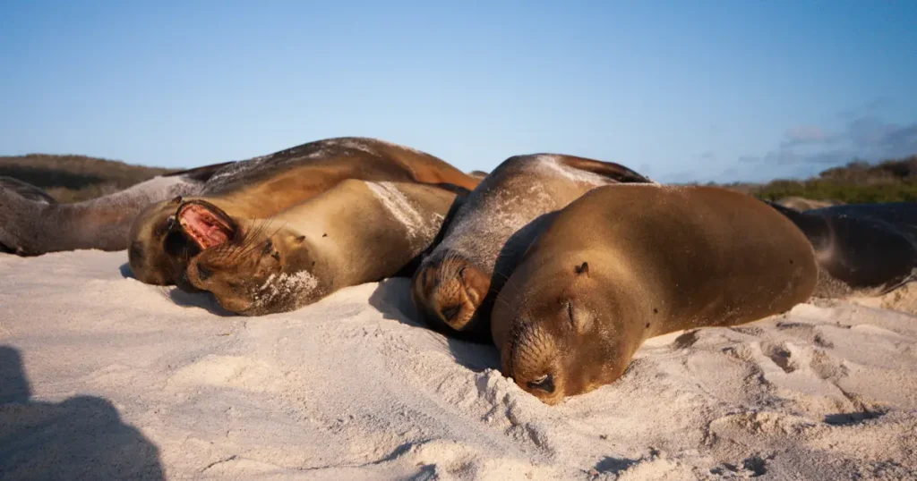
Visitor Site: Sea Lion Rookery
This coral sand beach is located about 10 minutes from the airport. A large number of sea lions rest in the sand and rocks along this coast. In addition to sea lions, birds such as Yellow Warblers, frigatebirds, and numerous species of finches can be seen.
Visitor Site: Interpretation Center
Opened to the public in 1998, the Galápagos National Park Visitor Center in San Cristóbal presents a complete and documented history of Galápagos, its ecosystems, flora and fauna. The Center focuses primarily on the history of the archipelago, from its volcanic origins to the present. Two interpretation panels, representing the natural and cultural history of the archipelago, are linked together in chronological order. The center includes a small auditorium, meeting rooms, and audiovisual equipment for the entire community to enjoy, for activities such as theater, exhibitions, and workshops (dance, painting, etc.) The Visitor Center is about a 20-minute walk from town and is open to the public every day from 7 am to 12 pm and 1:30 pm to 5 pm.
Visitor Site: Frigatebird Hill
A trail leading off from the Interpretation Center heads up Frigatebird Hill. Here it is possible to see Magnificent Frigate Birds and Great Frigate Birds in the same colony. This is the perfect place to compare and learn to distinguish them.
Visitor Site: Isla Lobos
This islet is a one-hour boat ride from San Cristóbal . It is a seasonal nesting location for blue-footed boobies, although it is named for the colony of sea lions sometimes present there. Fur seals are also sometimes present. Frigatebirds have also nested there in recent years. The islet has a tranquil and scenic atmosphere and is also a great place for snorkeling.
Visitor Site: Ochoa Beach
This site is a good place for recreation after a visit to Isla Lobos. It is a small rocky beach with white sand and calm waters. Migratory and coastal birds may be observed in the nearby lagoon. It is possible to see two species of crabs at the beach, the Ghost Crab and the Hermit Crab. Sea urchins are also very abundant. Snorkeling is particularly good here.
Visitor Site: Cerro Brujo
The primary attraction of this site is the coral sand beach. It is an excellent place to swim and snorkel. Cerro Brujo is the remains of a tuff cone. It is one of the first sites visited by Charles Darwin. Captain Fitzroy climbed to the top of the hill to scout out reefs. It has an impressive landscape, where it is often possible to see coastal and migratory birds, including pelicans, Blue-footed Boobies, and Swallow-tailed Gulls, as well as sea lions and marine iguanas. At times the lagoon is completely dry and deposits of salt may be found in the bottom. The people of Puerto Baquerizo Moreno used to use the lagoon as a salt mine.
Visitor Site: Sapho Bay (Puerto Grande)
This cove is located opposite Kicker Rock. Hermit Crabs are very common here, covering the area near the lagoons behind the beach. The cove is also a Blue-footed Booby feeding area. The cove has been a favorite site to anchor sailboats for centuries. There are many stories about buried treasures and about people that have come to look for them. To this day, there are large holes in the sand where people have excavated in search of treasure, and some say with success.
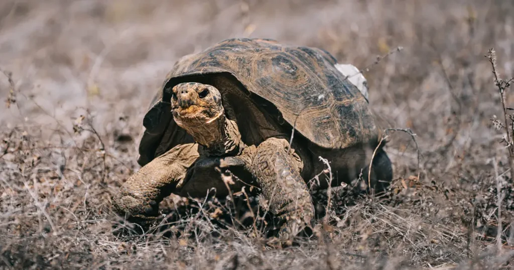
Visitor Site: Tortoise Reserve
The visit to the Tortoise Reserve is the longest hike on San Cristóbal. The walk from the beach to the Media Luna Cone is approximately 5 km one way and may be quite hot. This is an excellent site for viewing giant tortoises in their natural habitat. Many of the species endemic to San Cristóbal can be seen on this hike, including the giant tortoise, lava lizard, gecko, and mockingbird.
Visitor Site: Punta Pitt
At the far eastern end of San Cristóbal is Punta Pitt. Disembarking onto the small beach, visitors are confronted by the strong stench and cacophony of barking sea lions. This is a bachelor colony, and most are exhausted from fighting and mating. A steep gully leads up the cliff to a breeding ground for Boobies of all three varieties: Red-footed, Blue-footed and Nazca. It’s the only place in Galápagos where you can see all three species nesting together. Two species of frigatebirds are also present, as are Swallow-tailed Gulls and Storm Petrels. The view of sea lions from the top of the cliff over the beach is magnificent, as are the contours of the barren, wind-eroded peaks of the island. The trail across the Punta Pitt site offers a closer look at the hardy vegetation that manages to thrive in this volcanic wasteland. From Saltbush and spiny shrubs next to the beach the trail leads up to an area of Palo Santo trees, big yellow-green shrubs, tiny cacti and, in the dry season, carpets of red Vesuvius.
Visitor Site: El Junco Lagoon
El Junco is one of the few permanent fresh water lakes in Galápagos. It is located in the highlands of San Cristóbal at an altitude of 700 m, about 45 minutes by bus from Puerto Baquerizo Moreno. The lagoon has a surface area of 6 ha and a volume equivalent to 35 million liters of water. On the way to El Junco, visitors pass through several vegetation zones and the farming community, El Progreso, before reaching a beautiful panoramic site. It is an ideal spot for bird watching as well as enjoying the landscape. From the crater there is a view over most of the island, including the 900 m peak of Cerro San Joaquin. Punta Pitt, the most spectacular site on San Cristóbal, is visible to the northeast. El Junco is a good place to view White-cheeked Pintail Ducks, Common Gallinules, Miconia bushes, and endemic tree ferns. It is one of the best places to catch sight of the endangered Chatham mockingbird. Because of its fresh water, El Junco is one of the few places where you can see frigatebirds bathing in order to preen their feathers. The lake itself sits in a caldera (collapsed cone) of an extinct volcano and is about 300 m wide. It is generally accepted that the lake has been in existence since the end of the last northern ice age. The name El Junco is Spanish for sedge, which is present along the banks of the lake. It is filled by rainwater and therefore its depth varies with the seasons, with greater depth in the rainy season (October to May), with the highest rainfall usually in April.
During World War II, American soldiers stationed at the military base in Baltra traveled to El Junco in search of water. Despite having to travel hours each way in order to arrive at this freshwater lake, the soldiers made this trip often because San Cristóbal was the closest island where they could find this resource.
Visitor Site: Puerto Chino
This beach is located 24.5 km from Puerto Baquerizo Moreno, on the opposite side of the island. It is best to take food, water, and spend the day there. It is a beautiful, white beach in a lovely setting. On the drive over the island, visitors may stop at the old gravel mine where a restoration project is underway for two plant species: Calandrinia galapagosa and Lecocarpus leptolobus. There is a short trail from the parking area to the beach.
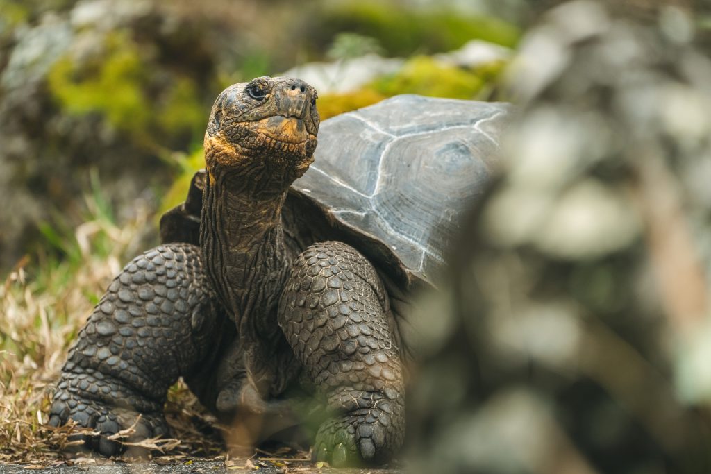
Visitor Site: Cerro Colorado Tortoise Reserve
Established by the National Park in 2003, the Galapaguera is a man-made breeding program for tortoises and an information center for visitors. Visitors can both observe giant tortoises living in a semi-natural habitat, but also learn about their origin, evolution, and threats by introduced animals.
Marine Sites
Four dive and/or snorkeling sites are located on the northwestern edge of San Cristóbal. These include: Kicker Rock or León Dormido, named for its characteristic shape of a sleeping lion, Isla Lobos, Islote Five Fingers, and Whale Rock. Kicker Rock is the most dramatic of the sites, with its vertical tuff cone, rising almost 148 m straight up out of the ocean. Tuff cones are created when boiling lava encounters a very cold ocean, resulting in an explosion. Erosion has split the rock into two parts, forming a narrow channel that small vessels can pass through. Circumnavigation provides the visitor with the best views of the rock. Blue-footed boobies, Nazca boobies, frigatebirds, and sea lions line the shore. This is an excellent location for snorkeling and diving; Manta Rays, sea turtles, and sharks are often spotted. At the other sites, divers can see sea lions, large numbers of pelagic fish species, Galápagos sharks, eagle rays, sea turtles, and at Islote Five Fingers, there is an abundant display of benthic organisms that is very colorful.
Conservation Site: Endangered plants
Due to the intensive use of the highlands of San Cristóbal and the presence of goats and aggressive introduced plants species, many native and endemic plant species have been decimated. In the late 1990s, a complete survey of the island was initiated to locate rare and endangered plant species. While many of the most endangered species were located, their survival remains questionable without reducing the population of feral ungulates, primarily goats. Following the successful completion of Project Isabela, the Galápagos National Park initiated goat eradication work on the other islands. Through the use of helicopters and land hunters in the last three years, they have successfully eliminated approximately 3,500 goats on San Cristóbal, with an estimated 3,000 still remaining in the northern half of the island. Their complete elimination is critical for the endangered plant species. New populations of the beautiful Critically Endangered Galápagos Rock Purslane, Calandrinia galapagosa (probably San Cristóbal’s rarest plant), and the Endangered Lecocarpus darwinii were discovered. Many were under pressure from goats. The population of Calandrinia was fenced in 2003, as were other small populations of the same species in 1992-93. More Calandrinia were found on the north coast in June 2002. As in the case of Santiago, these findings reveal the relatively poor state of knowledge of the Galápagos flora, and the urgent need for more baseline survey work.