Isabela Island
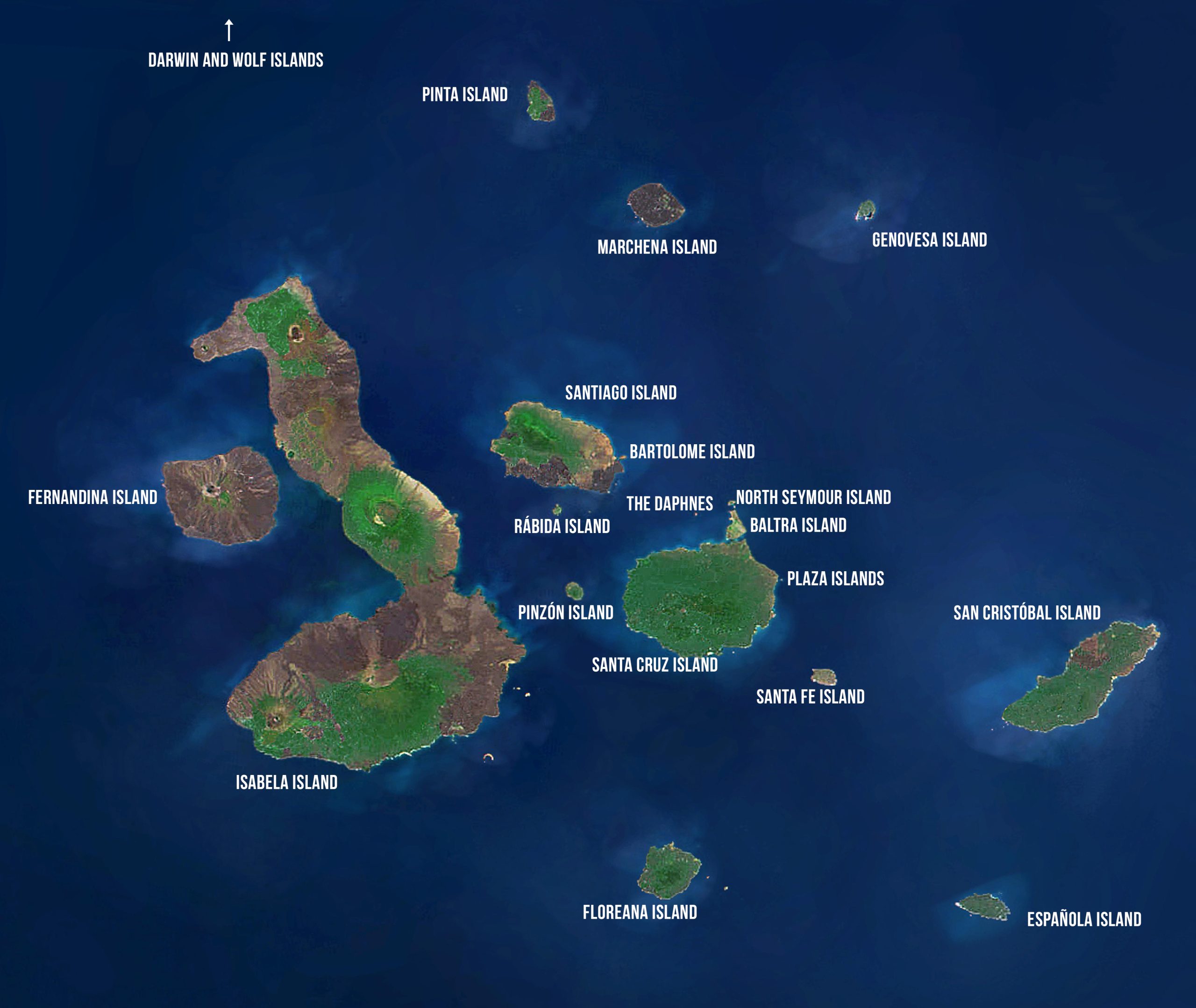
Isabela Island
Area: 4670 km2 or 1803 mi2
Maximum Altitude: 1707 m or 5600 ft
Human Population: Approximately 1800
HISTORY
The seahorse-shaped Isabela Island was originally named Albemarle Island for the Duke of Albemarle by Ambrose Cowley, one of the first men to ever set foot on the islands, in 1684. It is the largest of all the islands, measuring 120 km long and greater in size than all of the other islands combined. Tagus Cove on the northwestern side of the island provided a sheltered anchorage for pirates, buccaneers, whalers, and others. Darwin visited Tagus Cove in 1835. In 1893, Antonio Gil, a well-known Guayaquileño, arrived in Galápagos and after visiting the other islands, colonized southern Isabela, founding the town of Puerto Villamil on the southern coast and later Santo Tomás in the highlands. He named Villamil after the freedom fighter from Guayaquil, José de Villamil. Villamil began as a center for a lime production operation where they burned coral collected in the coastal waters. Santo Tomás was the center for a sulfur mine in the caldera and a nearby coffee plantation. The ventures were only somewhat profitable due to water limitations. By 1906, Santo Tomás had a population of 200 people who depended primarily on the wild livestock ranging the slopes of Sierra Negra and on the exploitation of sulfur. By 1974 there were nearly 450 residents on Isabela. This number has increased in each official census, with the total in the 2006 census reaching 1749.
GEOLOGY
One of the younger islands, Isabela Island was formed by the joining of six shield volcanoes — from north to south — Ecuador, Wolf, Darwin, Alcedo, Sierra Negra, and Cerro Azul. All of the volcanoes except Ecuador are still active. The western flanks of Ecuador Volcano have collapsed. Wolf Volcano, with an elevation of 1707 m, is the highest point in the Galápagos Archipelago. Both Wolf and Ecuador Volcanoes lie directly on the equator. Isabela is one of the more volcanically active islands. Eruptions have been recorded in the last fifty years for Wolf Volcano (1963 and 1982), Alcedo (1993), Sierra Negra (1963, 1979, and 2005), and Cerro Azul (1959, 1979, 1998, and 2008). Isabela provides visitors with excellent examples of the geologic forces that created the Galápagos Islands, including uplifts at Urbina Bay, tuff cones at Tagus Cove, and pumice on Alcedo Volcano.
TODAY
The majority of Isabela residents make their living by fishing, farming, and tourism. The center of population is on the southern coast at Puerto Villamil. Unlike the other large islands, the vegetation zones on Isabela do not follow the normal pattern. There are many relatively new lava fields and the surrounding soils have not developed sufficient nutrients to support the varied life zones found on other islands. In addition, the high elevations of Wolf and Cerro Azul Volcanoes reach above the cloud cover, resulting in an arid zone at the top of the island. The island’s rich fauna is beyond compare. It is home to more wild tortoises than all the other islands combined, with a separate species on each volcano. On the west coast of Isabela the upwelling of the nutrient-rich Cromwell Current creates a feeding ground for fish, whales, dolphins, and birds. These waters have long been known as the best place to see whales in the Galápagos. Some 16 species of whales have been identified in the area including humpbacks, sperms, sei, minkes and orcas.
CONSERVATION CHALLENGES
The immense size of Isabela increases the various conservation challenges found on other islands. Eradication of introduced species on an island this size can be extremely costly, as demonstrated during Project Isabela when successful eradication of goats and donkeys in northern Isabela was achieved. The continued presence of cats and rats on the island are causing problems for some of the more endangered and vulnerable birds, as well as snakes and other small reptiles. Of greatest concern is the survival of the mangrove finch, with a population of only 100 birds. Isabela has also been the center of much of the fishing controversies over the last two decades. Sea cucumber fishing was focused primarily in the nutrient-rich waters of the western coast of Isabela, especially the channel between Isabela and Fernandina. Although there have been many advances in fisheries management during the past ten years and much of the conflict is reduced or non-existent, achieving sustainability in marine ecosystems where fishing is permitted is still a work in progress.
City: Puerto Villamil
Villamil is the most beautiful townsite in Galápagos, with its long, white-sand, palm-lined beaches and several brackish-water lagoons frequented by pink flamingos, common stilts, whimbrels, white-cheeked pintails, and gallinules. The majority of Isabela’s residents live in the port town of Villamil. Until recently, the population was primarily involved in fishing and agriculture and had little connection to tourism. Then in the 1990s, development for tourism began in earnest. A small airport was completed in 1996 for inter-island flights. The number of hotels grew from a single hotel in 1980, to three in 1990, to 13 hotels by 2006. The number of bars and restaurants has grown from only two in 1980 and 1990 to 18 in 2006. However, the town still retains its relaxed attitude in contrast to Puerto Ayora on Santa Cruz and Puerto Baquerizo Moreno on San Cristóbal. There are several visitor sites accessible from town by car, foot, and dinghy.
Visitor Site: Sierra Negra
Sierra Negra Volcano is one of the most impressive examples of a volcano in the archipelago. Its caldera measures 10 km across from north to south and 9 km from east to west, and is considered to be the second largest caldera in the world. Visits to Sierra Negra require a 45-minute drive from Villamil followed by several hours of walking or horseback riding. The primary and easier-to-reach visitor site is Volcán Chico on the northeast corner of the volcano. Volcán Chico is a fissure of a parasitic cone that last erupted in November 1979. There visitors can walk on relatively recent lava flows. The site provides incredible vistas of the volcanoes of Isabela as well as Fernandina. At the other end of the caldera visitors who want to make a longer trek can view a system of fumaroles, known as the Sulfur Mine. Sulfur in the form of crystals has been deposited on the fumaroles for thousands of years.
Visitor Sites: Villamil Lagoons, Tortoise Center, Wall of Tears, and Tintoreras
Four visitor sites are easily accessible from Puerto Villamil — Villamil Lagoons, Tortoise Center, Wall of Tears, and Tintoreras. The first three are accessible by foot while a panga ride is required to reach Tintoreras. An interpretive trail runs from town, through the Lagoons, and ends at the Tortoise Center, approximately 1.5 km from town. The beach and lagoons near Villamil are the best sites in the archipelago to view migratory birds. Black-necked stilts and flamingos are two of the most common resident species.
The Tortoise Center of Isabela was completed in 1994 and houses tortoises from the populations of southern Isabela, many of which have experienced relatively high levels of poaching within the last 10-20 years. Visitors can see both hatchlings tortoises and the older breeding animals.
The Wall of Tears is an interesting historical site, usually visited by tourists staying in Villamil for a few days. It is a 6-km walk (one-way) from town (it is possible to get a ride half way). The trail passes the Villamil cemetery shortly after leaving town, with tombs of the first settlers. About half way to the Wall, the trail passes a white sand beach with surrounding lagoons where all four species of mangroves that exist in Galapagos can be seen. The trail continues through the dry zone until reaching the Wall. A penal colony existed on Isabela from 1944 to 1959. The Wall of Tears was built by the prisoners to keep them busy. It stand 5-6 m high, 3 m wide and is approximately 100 m long. It is a testament to a period of cruelty and torture.
To reach Tintoreras, a group of small islets off the coast, visitors must take a dinghy ride. The small bay of completely tranquil turquoise water provides habitat for sea lions, sea turtles, marine iguanas, rays, and other species. The bay is connected to a shallow crevice of crystalline water that is frequented by sharks. The relatively short loop trail is primarily on lava. Marine iguanas nest on the islet and sharks can be seen in the crevice where they rest during the day.
Visitor Site: Moreno Point
At first glance, Moreno Point appears to be a lifeless lava flow typical of hundreds of others in the archipelago. However, its black surface at the base of Cerro Azul is dotted with numerous lagoons containing a wide variety of life. Commonly seen species include flamingos, paint-billed crakes, white-cheeked pintails, and common gallinules. The trail branches at a couple of points to enable the visitor to observe more of the area. The lava flow is very young and has several endemic species known to be early pioneers in barren lava fields.
Visitor Site: Elizabeth Bay and the Mariela Islets
While no visits are allowed on land, this visitor site is included in many tours to the western islands. The visit is by dinghy and snorkeling is also allowed. The lagoon at Elizabeth Bay is a resting and feeding place for sea turtles. The mangroves surrounding it are principally red and black mangroves. Visitors will also see rays, flightless cormorants, penguins, pelicans, lava herons, and other species. The Marielas Islets, just outside the bay, are home to many penguins and visitors can usually observe them both on shore and swimming nearby.
Visitor Site: Urbina Bay
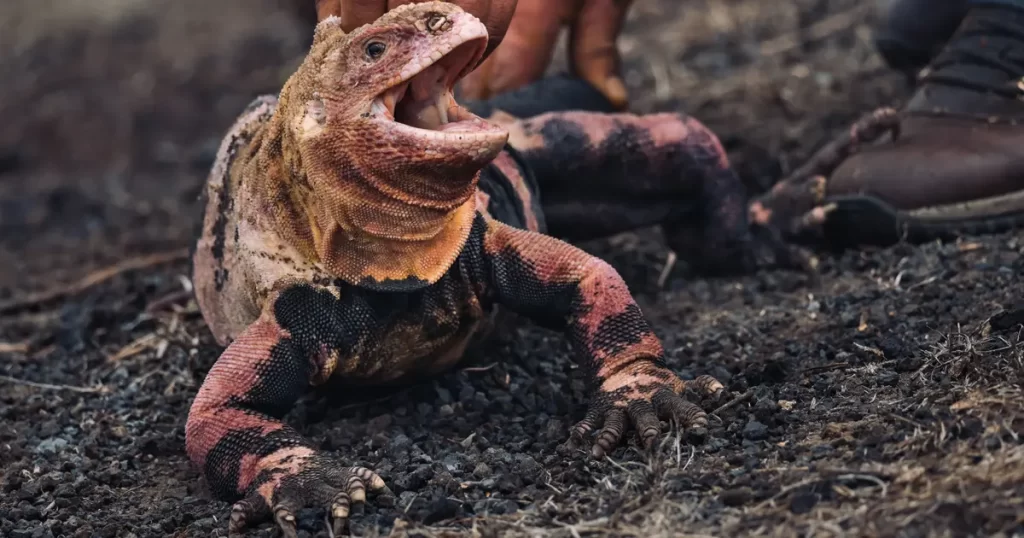
A long, loop trail leads the visitor away from the beach and into the arid zone of the island. Here visitors may have the chance to see giant tortoises, land iguanas, and flightless cormorants (near the coast). The most unique feature at Urbina Bay is the result of an uplift of the island in 1954, when a 6-km stretch of coral reef was raised up 5 m, stranding the coral heads above sea level with the new coastline more than a km away. However, exposed to the air, the coral heads are rapidly deteriorating.
Visitor Site: Tagus Cove
A favorite site of the early pirates and whalers, many of these early visitors wrote their names on the cliffs along the shore. The oldest include the Phoenix in 1836 and the Genie in 1846. The name Tagus comes from an English war ship that passed by the islands in 1814 looking for giant tortoises. A short, steep hike passes Darwin Lake, which sits within a tuff cone. It is approximately 9 m deep and filled with salt water. This site is an excellent place for viewing landbirds, including ground and tree finches, hawks, yellow warblers, large-billed flycatchers and even sometimes the woodpecker finch. An occasional land iguana or giant tortoise can also sometimes be observed. A dinghy ride along the cliffs provides viewing of the geologic features as well as penguins and other bird species.
Marine Site: Punta Vicente Roca
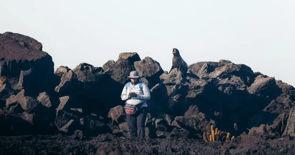
Visits at Punta Vicente Roca are solely in the water – by dinghy or SCUBA diving. The geological formations are very impressive and provide a beautiful backdrop for numerous nesting birds, including Blue-footed and Nazca boobies, gulls, storm petrels, and Brown Noddy Terns. The water in the western archipelago is cold due to the upwelling of the Cromwell Current from the west, offering an abundant food supply for marine species. It is common to observe “feeding frenzies”, with groups of whales, dolphins, sea lions, tunas, Blue-footed and Nazca boobies, pelicans and other marine birds feeding simultaneously. To the south of the cove, there is a small colony of fur seals.
Visitor Site: Albemarle Point
Albemarle Point is a seldom visited site at the northern end of Isabela. During World War II the United States constructed a radar base at Albemarle Point. Visitors can walk to the ruins of the radar base. Marine iguanas on the north end of Isabela are some of the largest in the archipelago.
Marine Dive Sites
Seven dive sites are located around Isabela. These include: the Four Brothers, Tortuga Island, Urbina Bay, Tagus Cove, Punta Vicente Roca, Roca Redondo, and Cape Marshall. Many of these sites provide viewing of various species of sharks, sea lions, sting rays, moray eels, sea turtles, cormorants, penguins, manta rays, and many other species. Of particular interest is Roca Redondo, a small island to the north of Isabela, where many shark species can be seen, as well as gas fumeroles. Tagus Cove provides viewing of sea horses, sponges, corals, and other species.
Conservation Site: Alcedo Volcano
Alcedo Volcano was a visitor site of the Galápagos National Park until the start of Project Isabela in the late 1990s. Visitors could make the many hour hike to the rim to view the caldera and experience the giant tortoises. One of the largest tortoise populations in Galápagos lives on and in Alcedo – both on the outer and inner slopes as well as along the rim and on the floor of the caldera. For decades this population survived with the presence of feral donkeys. However goats finally crossed the Perry Isthmus from Sierra Negra to northern Isabela sometime in the late 1970s. The population explosion that resulted when they reached the lush highlands of Alcedo devastated the landscape, destroying the forests and causing massive erosion. The tortoises and much of the natural world of Alcedo was endangered. After years of planning, preparation, and training, the field work of Project Isabela, aimed at eliminating large mammalian exotics from northern Isabela, began in April 2004. By 2006 the job was completed – goats and donkeys no longer roamed the northern portion of the island. The vegetation is recovering rapidly and both reptile and bird species are beginning to thrive once again. Perhaps one day the Park will re-open this amazing visitor site.
Conservation Site: Mangrove Finches
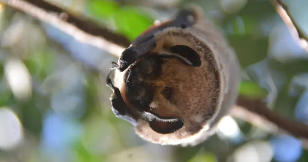
Although most land birds in Galápagos are still relatively abundant, the Mangrove Finch is considered one of the rarest birds in the world, with less than 100 individuals in existence. It inhabits two small sections of coastal mangrove forests at Playa Tortuga Negra and Caleta Black on the northwest coast of Isabela Island. To ensure the long-term conservation of this species, the Charles Darwin Foundation and the Durrell Wildlife Conservation Trust began in-depth studies in 2006 and have confirmed that populations still exist at three sites on Isabela. However, the finch’s natural habitat and the species itself face threats from climate change, human activities, invasive species, and disease. If this species were to be lost, it would be the first bird species to become extinct in Galápagos since Darwin visited the islands nearly 175 years ago.
As part of the Mangrove Finch Captive Rearing Program, the first mangrove finch eggs were collected in the wild and hatched in captivity in early 2014, followed by a release of 15 captive-reared mangrove finches back to their native home on Isabela. Concurrently, research is ongoing to discover means of controlling one of the biggest threats to mangrove finches and other land birds: the invasive avian parasite Philronis downsi.
Conservation Site: Penguins and Cormorants
The on-going, collaborative penguin-cormorant project is crucial for the long-term conservation of these vulnerable, flightless species. Their inability to move easily within the archipelago and their vulnerability to predation and global climate change make them excellent indicator species for ecosystem health. Annual censuses on Fernandina and the western coast of Isabela provide essential data to determine whether the populations are stable, increasing, or decreasing, and to diagnose the causes of changes in their populations and provide the Galápagos National Park with scientifically-based recommendations for management to ensure the protection of these two endemic seabird species and their habitat.